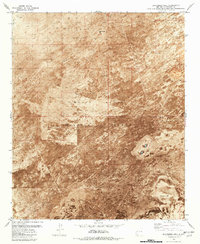
1981 Map of Blakemore Well
USGS Topo · Published 1981About this map
White Sands Missile Range dominates this landscape in Socorro County, New Mexico, where the arid environment is defined by its scarce water sources and volcanic history. The topography is marked by significant lava flows in the southwest, contrasting with the scattered outposts that define local land use. Water access points, including Blakemore Well, Cain Well, and Blue Well, serve as the primary human identifiers across this expansive terrain.
Find a feature on this map
21 named features on this map. Tap any name to fly to it.
Don’t see what you’re looking for? This feature index may not catch every label — zoom into the map to look around manually.
Map Details
Editions of this 1981 Blakemore Well Map
This is the sole edition of this map. No revisions or reprints were ever made.
Other maps of this area

1916 · Salinas Peak
USGS Topo · 1:125,000

1948 · Granjean Well
USGS Topo · 1:62,500

1948 · Val Verde
USGS Topo · 1:62,500

1948 · Malpais Well
USGS Topo · 1:62,500

1948 · Salinas Peak
USGS Topo · 1:62,500

1954 · Tularosa
USGS Topo · 1:250,000

1958 · Tularosa
USGS Topo · 1:250,000

1981 · Fairview Mountain
USGS Topo · 1:24,000
1981 · Greens Baber Well
USGS Topo · 1:24,000

1981 · Granjean Well
USGS Topo · 1:24,000