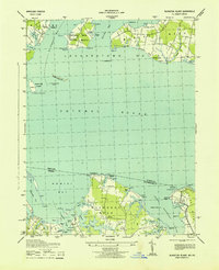
1943 Map of Blakiston Island
USGS Topo · Published 1943About this map
Blakiston Island stands as a focal point in the Potomac River, marked by the Blakiston I Lighthouse and the expansive Heron Island Bar. During the early 1940s, the landscape of St. Mary's County reflects both its maritime heritage and wartime utility, notably with the Proving Ground established on Newtown Neck. This peninsula, bounded by St Clement Bay and Breton Bay, shows a mix of agricultural clearings and tactical military space. Across the river on the Virginia shore, the intricate drainage of Machodoc Neck and Coles Neck is visible. Small coastal communities like Milestown and Coles Point highlight the era's reliance on these waterways. The map documents numerous family-named landmarks and navigational aids, including Icehouse Pt Lt, which served the active fishing and transport vessels navigating Nomini Creek and Lower Machodoc Creek.
Find a feature on this map
58 named features on this map. Tap any name to fly to it.
Don’t see what you’re looking for? This feature index may not catch every label — zoom into the map to look around manually.
Map Details
Editions of this 1943 Blakiston Island Map
This is the sole edition of this map. No revisions or reprints were ever made.
Other maps of this area

1892 · Leonardtown
USGS Topo · 1:62,500

1892 · Piney Point
USGS Topo · 1:62,500

1892 · Montross
USGS Topo · 1:62,500

1894 · Wicomico
USGS Topo · 1:62,500

1894 · Piney Point
USGS Topo · 1:62,500

1895 · Wicomico
USGS Topo · 1:62,500

1895 · Leonardtown
USGS Topo · 1:62,500

1895 · Nomini
USGS Topo · 1:125,000

1895 · Piney Point
USGS Topo · 1:62,500

1895 · Montross
USGS Topo · 1:62,500