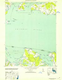
1953 Map of Blakiston Island
USGS Topo · Published 1953About this map
Blakiston Island and its lighthouse stand as central landmarks in the Potomac River, bridging the maritime life of Maryland's Milestown Neck with the Virginia shoreline of Machodoc Neck. This mid-century survey captures a landscape of peninsulas and deep-water inlets, featuring the Proving Ground near Newtown and the agricultural reaches of Cople. Navigational aids like the Huggins Point Lt and Blakiston Island Shoal Lt highlight the importance of the river as a commercial artery.
Find a feature on this map
87 named features on this map. Tap any name to fly to it.
Don’t see what you’re looking for? This feature index may not catch every label — zoom into the map to look around manually.
Map Details
Editions of this 1953 Blakiston Island Map
2 editions found
Other maps of this area

1892 · Leonardtown
USGS Topo · 1:62,500

1892 · Piney Point
USGS Topo · 1:62,500

1892 · Montross
USGS Topo · 1:62,500

1894 · Wicomico
USGS Topo · 1:62,500

1894 · Piney Point
USGS Topo · 1:62,500

1895 · Wicomico
USGS Topo · 1:62,500

1895 · Leonardtown
USGS Topo · 1:62,500

1895 · Nomini
USGS Topo · 1:125,000

1895 · Piney Point
USGS Topo · 1:62,500

1895 · Montross
USGS Topo · 1:62,500