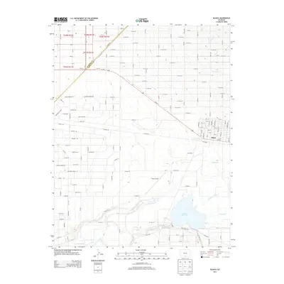
2013 Map of Blanca
USGS Topo · Published 2013About this map
Blanca sits at a geographic crossroads in the San Luis Valley, where a grid of streets like Main St and Railroad St meets the open high-desert terrain. The landscape is defined by its water management and drainage patterns, with the Smith Reservoir serving as a significant southern landmark. This 2013 survey illustrates the agricultural and hydrologic infrastructure essential to the region, featuring the Garland Ditch, Newton Ditch, and the winding paths of Sangre de Cristo Cr and Trinchera Cr. The settlement of McClintock and the Blanca Airport further anchor the valley's development. An interesting cultural layer is found in the naming of rural roads, which reflect a wider Colorado geography with labels such as Grand Junction Rd, Manitou Springs Rd, and Colorado Springs Rd, suggesting a systematic naming convention for the county's arterial routes.
Find a feature on this map
78 named features on this map. Tap any name to fly to it.
Don’t see what you’re looking for? This feature index may not catch every label — zoom into the map to look around manually.
Map Details
Editions of this 2013 Blanca Map
This is the sole edition of this map. No revisions or reprints were ever made.
Other maps of this area

1889 · Huerfano Park
USGS Topo · 1:125,000

1892 · Huerfano Park
USGS Topo · 1:125,000

1954 · Trinidad
USGS Topo · 1:250,000

1955 · Trinidad
USGS Topo · 1:250,000

1958 · Trinidad
USGS Topo · 1:250,000

1959 · Trinidad
USGS Topo · 1:250,000

1965 · Blanca
USGS Topo · 1:24,000

1965 · Baldy
USGS Topo · 1:24,000

1965 · Lasauses
USGS Topo · 1:24,000

1965 · Blanca SE
USGS Topo · 1:24,000