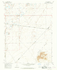
1965 Map of Lasauses
USGS Topo · Published 1968About this map
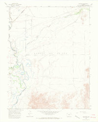
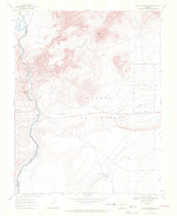
The settlement of Lasauses serves as a focal point in this 1960s survey of the San Luis Valley, where the Rio Grande and Conejos River converge. This landscape is defined by its complex hydrology, featuring numerous flowing wells and the man-made Conejos Diversion cutting across the alluvial plain. The eastern portion of the sheet is dominated by the volcanic terrain of the Sangre De Cristo Hills, while the northwestern corner preserves the marshlands of the Alamosa National Wildlife Refuge. The map traces early land divisions through a prominent Grant Boundary and includes the small, family-oriented Becker Cem near Hansen Bluff, providing valuable data for genealogists interested in the early ranching and agricultural communities of Costilla County. Meandering watercourses like Trinchera Creek illustrate the historical importance of water management in this arid high-altitude region.
Find a feature on this map
17 named features on this map. Tap any name to fly to it.
Don’t see what you’re looking for? This feature index may not catch every label — zoom into the map to look around manually.
Map Details
Editions of this 1965 Lasauses Map
3 editions found
Other maps of this area

1954 · Trinidad
USGS Topo · 1:250,000

1955 · Trinidad
USGS Topo · 1:250,000

1958 · Trinidad
USGS Topo · 1:250,000

1959 · Trinidad
USGS Topo · 1:250,000
1965 · Blanca
USGS Topo · 1:24,000
1965 · Baldy
USGS Topo · 1:24,000
1965 · Blanca SE
USGS Topo · 1:24,000
1966 · Alamosa East
USGS Topo · 1:24,000
1967 · Manassa NE
USGS Topo · 1:24,000
1967 · Mesito Reservoir
USGS Topo · 1:24,000