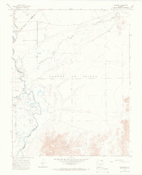
1965 Map of Lasauses
USGS Topo · Published 1968About this map
The settlement of Lasauses sits near the southern edge of this mid-1960s survey, marking a point where the Rio Grande and the Conejos River converge in the San Luis Valley. This landscape is defined by the complex movement of water, from the Trinchera Creek in the north to the managed flow of the Conejos Diversion. The map details the transition from the protected wetlands of the Alamosa National Wildlife Refuge and the heights of Hansen Bluff down into the river bottomlands. Numerous Flowing Wells are mapped throughout the basin, illustrating the reliance on artesian water for local agriculture and livestock. In the eastern and southern reaches, the rising topography of the Sangre De Cristo and the San Luis Hills provides a stark contrast to the riparian corridor. Local history is anchored by features like the Becker Cem and several Gaging Sta installations that monitor the vital river system.
Find a feature on this map
19 named features on this map. Tap any name to fly to it.
Don’t see what you’re looking for? This feature index may not catch every label — zoom into the map to look around manually.
Map Details
Editions of this 1965 Lasauses Map
3 editions found
Other maps of this area

1954 · Trinidad
USGS Topo · 1:250,000

1955 · Trinidad
USGS Topo · 1:250,000

1958 · Trinidad
USGS Topo · 1:250,000

1959 · Trinidad
USGS Topo · 1:250,000

1965 · Blanca
USGS Topo · 1:24,000

1965 · Baldy
USGS Topo · 1:24,000

1965 · Lasauses
USGS Topo · 1:24,000

1965 · Blanca SE
USGS Topo · 1:24,000
1966 · Alamosa East
USGS Topo · 1:24,000

1967 · Manassa NE
USGS Topo · 1:24,000