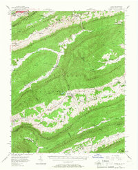
1956 Map of Bland
USGS Topo · Published 1967About this map
Bland serves as the focal point of this mid-century survey, situated at the junction of Town Creek and Walker Creek. The surrounding landscape is dominated by the ridges of Brushy Mountain and Walker Mountain, much of which is encompassed by the Jefferson National Forest. This era shows a settled mountain landscape where community life revolved around numerous rural congregations such as Nebo Ch, Honaker Chapel, and Pine Grove Ch. Evidence of local industry and infrastructure is present through the Stone Quarry near Central and the Telephone Line crossing Round Mountain. To the north, the burgeoning edge of Bluefield and the campus of Bluefield College mark the boundary with West Virginia, while the high elevations of East River Mtn and Buckhorn Mountain define the rugged corridor for Wolf Creek.
Find a feature on this map
84 named features on this map. Tap any name to fly to it.
Don’t see what you’re looking for? This feature index may not catch every label — zoom into the map to look around manually.
Map Details
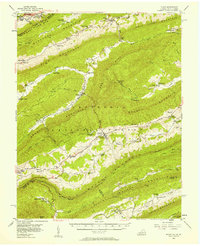
Editions of this 1956 Bland Map
2 editions found
Other maps of this area

1887 · Pocahontas
USGS Topo · 1:125,000

1889 · Hillsville
USGS Topo · 1:125,000

1889 · Wytheville
USGS Topo · 1:125,000

1890 · Dublin
USGS Topo · 1:125,000

1891 · Pocahontas
USGS Topo · 1:125,000

1891 · Dublin
USGS Topo · 1:125,000

1892 · Hillsville
USGS Topo · 1:125,000

1892 · Wytheville
USGS Topo · 1:125,000

1894 · Pocahontas
USGS Topo · 1:125,000

1895 · Pocahontas
USGS Topo · 1:125,000