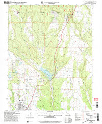
2001 Map of Blanding North
USGS Topo · Published 2004About this map
Blanding anchors the southern edge of this landscape, where the northern residential expansion meets the higher elevations of the Manti-La Sal National Forest. The 2001 revision highlights a complex water management system vital to this desert environment, centered on the Recapture Reservoir and the Blanding City Reservoirs, which are fed by an intricate network of an Aqueduct and Canal systems. The rugged geography is defined by deep incisions like Devils Canyon and Alkali Canyon, separating high plateaus such as Mustang Mesa and The Park. Utility and communication infrastructure is prominent, including a Communication Tower near a Gravel Pit and several Pipeline corridors, reflecting the area's mid-century and later industrial development. Local landmarks such as Pinenut Knoll and the Athletic Field provide specific points of reference for those tracing the town's modern footprint.
Find a feature on this map
38 named features on this map. Tap any name to fly to it.
Don’t see what you’re looking for? This feature index may not catch every label — zoom into the map to look around manually.
Map Details
Editions of this 2001 Blanding North Map
This is the sole edition of this map. No revisions or reprints were ever made.
Other maps of this area

1886 · Abajo
USGS Topo · 1:250,000

1892 · Abajo
USGS Topo · 1:250,000

1893 · Abajo
USGS Topo · 1:250,000

1935 · Elk Ridge
USGS Topo · 1:96,000

1940 · Elk Ridge
USGS Topo · 1:125,000

1954 · Elk Ridge 1 SE
USGS Topo · 1:24,000
1954 · Mt Linnaeus
USGS Topo · 1:62,500

1955 · Verdure 2 SE
USGS Topo · 1:24,000

1955 · Verdure 3 SE
USGS Topo · 1:24,000

1955 · Verdure 3 NE
USGS Topo · 1:24,000