
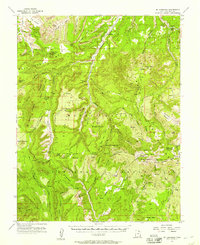
1954 Map of Elk Ridge 1 SE
USGS Topo · Published 1954About this map
Mt. Linnaeus dominates the central landscape of this 1954 survey, rising within the expansive boundaries of the Manti-La Sal National Forest. This preliminary edition captures a remote part of San Juan County during a period of active land management and ranching. The presence of Bayles Ranch and various water features like the Irrigation Ditch and several stock ponds suggests a landscape shaped by high-altitude livestock grazing.
Find a feature on this map
22 named features on this map. Tap any name to fly to it.
Don’t see what you’re looking for? This feature index may not catch every label — zoom into the map to look around manually.
Map Details
Editions of this 1954 Elk Ridge 1 SE Map
This is the sole edition of this map. No revisions or reprints were ever made.
Other maps of this area

1886 · Abajo
USGS Topo · 1:250,000

1892 · Abajo
USGS Topo · 1:250,000

1893 · Abajo
USGS Topo · 1:250,000

1935 · Elk Ridge
USGS Topo · 1:96,000

1940 · Elk Ridge
USGS Topo · 1:125,000

1954 · Elk Ridge 4 NW
USGS Topo · 1:24,000

1954 · Elk Ridge 1 SW
USGS Topo · 1:24,000

1954 · Elk Ridge 1 NW
USGS Topo · 1:24,000

1954 · Elk Ridge 1 NE
USGS Topo · 1:24,000
1954 · Mt Linnaeus
USGS Topo · 1:62,500