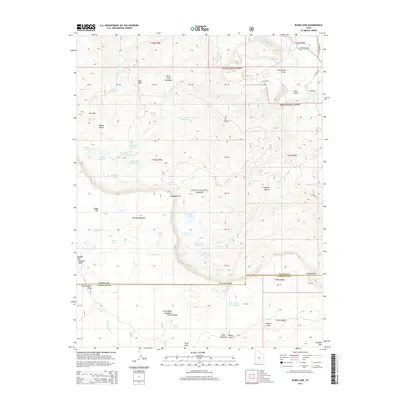
2014 Map of Blind Lake
USGS Topo · Published 2014About this map
Dixie National Forest dominates this high-elevation landscape on the border of Wayne and Garfield counties. The topography is defined by the massive basalt plateau of Boulder Mtn, where numerous alpine lakes and man-made impoundments provide critical water storage. High points like Bluebell Knoll and Donkey Point overlook a complex drainage system where Donkey Cr and Fish Cr carve through the terrain. Evidence of seasonal grazing and water management is visible through features such as Hickman Pasture, Donkey Meadows, and Jim Larson Reservoir. The map illustrates the transition from the high meadows of Birch Creek Meadows and Dog Flat down toward the lower slopes and canyons. Blind Lake, the largest natural water body in the area, sits prominently below the eastern rim of the plateau, surrounded by a network of smaller ponds like Pear Lake and Curler Lake.
Find a feature on this map
72 named features on this map. Tap any name to fly to it.
Don’t see what you’re looking for? This feature index may not catch every label — zoom into the map to look around manually.
Map Details
Editions of this 2014 Blind Lake Map
This is the sole edition of this map. No revisions or reprints were ever made.
Other maps of this area

1885 · Fish Lake
USGS Topo · 1:250,000

1896 · Fish Lake
USGS Topo · 1:250,000

1952 · Notom 3 SW
USGS Topo · 1:24,000

1952 · Loa 1 SE
USGS Topo · 1:24,000

1952 · Notom 3 NW
USGS Topo · 1:24,000

1952 · Notom 2 SE
USGS Topo · 1:24,000

1952 · Notom 2 SW
USGS Topo · 1:24,000

1952 · Notom 3 SE
USGS Topo · 1:24,000

1952 · Notom 3 NE
USGS Topo · 1:24,000

1952 · Grover
USGS Topo · 1:62,500