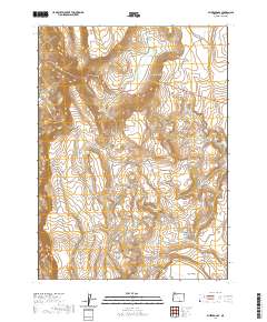
2020 Map of Blizzard Gap
USGS Topo · Published 2020About this map
Blizzard Gap sits at the heart of this high-desert landscape in Lake County, where water management defines the arid terrain. The map reveals a complex network of stock water resources and natural catchments, including the M C Reservoir and L H Reservoir, which are vital for land use in this open range. These man-made features are interspersed with natural landmarks like Moon Lake and Pinto Lake, illustrating the careful balance of water scarcity in the Great Basin region.
Find a feature on this map
32 named features on this map. Tap any name to fly to it.
Don’t see what you’re looking for? This feature index may not catch every label — zoom into the map to look around manually.
Map Details
Editions of this 2020 Blizzard Gap Map
This is the sole edition of this map. No revisions or reprints were ever made.
Other maps of this area

1889 · Long Valley
USGS Topo · 1:250,000

1954 · Vya
USGS Topo · 1:250,000

1955 · Adel
USGS Topo · 1:250,000

1957 · Adel
USGS Topo · 1:250,000

1958 · Vya
USGS Topo · 1:250,000

1958 · Adel
USGS Topo · 1:250,000

1962 · Vya
USGS Topo · 1:250,000

1962 · Adel
USGS Topo · 1:250,000
1966 · Rye Creek
USGS Topo · 1:24,000
1966 · Little Coleman Canyon
USGS Topo · 1:24,000