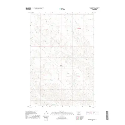
2020 Map of Blizzard Reservoir
USGS Topo · Published 2020About this map
Blizzard Reservoir and the adjacent Big Snowy Reservoir anchor this section of Phillips County, where the landscape is defined by the intricate drainage patterns of the Missouri River watershed. The terrain is deeply incised by Nichols Coulee and several seasonal watercourses, including the winding paths of Sevenmile Creek and Spring Creek. These catchments and coulees are central to the region's ranching and land management history, reflecting the necessary infrastructure for water storage in this semi-arid environment. The map details the Public Land Survey System grid across portions of Township 23 North, Range 26 East and neighboring ranges, showing the administrative framework that governs this rural Montana expanse. The sparse distribution of named features underscores the open, undeveloped character of the territory, where geography is dominated by natural landforms rather than dense settlement.
Find a feature on this map
10 named features on this map. Tap any name to fly to it.
Don’t see what you’re looking for? This feature index may not catch every label — zoom into the map to look around manually.
Map Details
Editions of this 2020 Blizzard Reservoir Map
This is the sole edition of this map. No revisions or reprints were ever made.
Other maps of this area

1954 · Lewistown
USGS Topo · 1:250,000

1959 · Lewistown
USGS Topo · 1:250,000

1965 · Dry Coulee
USGS Topo · 1:24,000

1965 · Dry Fork Ridge
USGS Topo · 1:24,000

1965 · Lake Reservoir
USGS Topo · 1:24,000

1971 · Robinson School
USGS Topo · 1:24,000

1971 · Bison Bone Reservoir
USGS Topo · 1:24,000

1971 · Blizzard Reservoir
USGS Topo · 1:24,000

1971 · Kepple Bottoms
USGS Topo · 1:24,000
1971 · Sagebrush Reservoir
USGS Topo · 1:24,000