
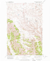
1971 Map of Blizzard Reservoir
USGS Topo · Published 1974About this map
The Charles M Russell National Wildlife Range dominates the southern landscape of this Phillips County region, preserving a rugged drainage network during the early 1970s. The map illustrates a high-plains environment defined by essential water management features, including the Blizzard Res in the north and the Big Snowy Reservoir further south. These artificial catchments, along with a Flowing Well and numerous drainage coulees like Nichols Coulee, reflect the critical importance of water infrastructure for cattle ranching and wildlife in this semi-arid Montana terrain. The established Nichols Coulee Camp provides a specific point of human activity within the expansive protected range, situated among the draws of Spring Creek and C K Creek.
Find a feature on this map
9 named features on this map. Tap any name to fly to it.
Don’t see what you’re looking for? This feature index may not catch every label — zoom into the map to look around manually.
Map Details
Editions of this 1971 Blizzard Reservoir Map
This is the sole edition of this map. No revisions or reprints were ever made.
Other maps of this area

1954 · Lewistown
USGS Topo · 1:250,000

1959 · Lewistown
USGS Topo · 1:250,000

1965 · Dry Coulee
USGS Topo · 1:24,000

1965 · Dry Fork Ridge
USGS Topo · 1:24,000

1965 · Lake Reservoir
USGS Topo · 1:24,000

1971 · Robinson School
USGS Topo · 1:24,000

1971 · Bison Bone Reservoir
USGS Topo · 1:24,000

1971 · Kepple Bottoms
USGS Topo · 1:24,000
1971 · Sagebrush Reservoir
USGS Topo · 1:24,000

1971 · Hanson Flat
USGS Topo · 1:24,000