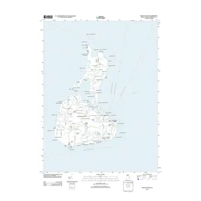
2012 Map of Block Island
USGS Topo · Published 2012About this map
Block Island stands at the eastern entrance of Long Island Sound, defined by its complex network of freshwater ponds and maritime landmarks. The central settlement of New Shoreham and the Old Harbor Landing area serve as the island's primary hubs, while the interior is marked by historic sites such as the Beacon Hill Stone Tower and several ancestral burial grounds including Island Cem and Dodge Cem. Navigational safety is emphasized by the presence of both the North Lighthouse on Sandy Point and the Block Island Southeast Lighthouse.
Find a feature on this map
148 named features on this map. Tap any name to fly to it.
Don’t see what you’re looking for? This feature index may not catch every label — zoom into the map to look around manually.
Map Details
Editions of this 2012 Block Island Map
This is the sole edition of this map. No revisions or reprints were ever made.
Other maps of this area

1889 · Charlestown
USGS Topo · 1:62,500

1889 · Newport
USGS Topo · 1:62,500

1889 · Block Island
USGS Topo · 1:62,500

1894 · Block Island
USGS Topo · 1:62,500

1894 · Newport
USGS Topo · 1:62,500

1899 · Block Island
USGS Topo · 1:62,500

1904 · Newport
USGS Topo · 1:62,500

1919 · Charlestown
USGS Topo · 1:62,500
1920 · Newport
USGS Topo · 1:62,500

1921 · Charlestown
USGS Topo · 1:62,500