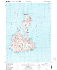
1998 Map of Block Island
USGS Topo · Published 1999About this map
Block Island serves as a critical nautical intersection at the end of the 20th century, defined by its maritime infrastructure and complex shoreline. The landscape is bookended by history, from the Block Island N Lighthouse at Sandy Pt to the Block Island SE Lighthouse near Mohegan Bluffs State Park. The island's geography is dominated by the Great Salt Pond, which nearly bisects the landmass and connects the New Harbor to the sea. The settlement of New Shoreham remains the central hub, supported by essential services like the Block Island State Airport and the U S Coast Guard Sta. Smaller inland features like Island Cem and Sheffield Cem provide valuable genealogical anchors for researchers tracing families in this island community. Extensive conservation areas, including the Block Island National Wildlife Refuge, reflect the preservation of the island's unique ecology alongside its active harbor economy.
Find a feature on this map
107 named features on this map. Tap any name to fly to it.
Don’t see what you’re looking for? This feature index may not catch every label — zoom into the map to look around manually.
Map Details
Editions of this 1998 Block Island Map
This is the sole edition of this map. No revisions or reprints were ever made.
Other maps of this area

1889 · Charlestown
USGS Topo · 1:62,500

1889 · Newport
USGS Topo · 1:62,500

1889 · Block Island
USGS Topo · 1:62,500

1894 · Block Island
USGS Topo · 1:62,500

1894 · Newport
USGS Topo · 1:62,500

1899 · Block Island
USGS Topo · 1:62,500

1904 · Newport
USGS Topo · 1:62,500

1919 · Charlestown
USGS Topo · 1:62,500
1920 · Newport
USGS Topo · 1:62,500

1921 · Charlestown
USGS Topo · 1:62,500