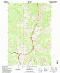
1994 Map of Blodgett Mountain
USGS Topo · Published 1997About this map
Blodgett Mountain and the surrounding high peaks of the Bitterroot Range dominate this 1994 survey, documenting the primitive landscape within the Selway Bitterroot Wilderness. This high-altitude terrain is defined by a series of glacial cirques containing alpine waters like Mill Lake and Fred Burr Lake, which feed the drainages flowing east and west from the continental divide. The map provides a detailed look at the jurisdictional overlap where the Nez Perce National Forest meets the Bitterroot National Forest, marked by the dividing line between Idaho and Montana. Navigation across this wilderness is limited to a network of primitive routes, including the Pack Trail near Printz Ridge. Genealogists and hikers can trace the historical access points to remote summits like Shattuck Mountain and Frog Peak, as well as the transition from the Stevensville Ranger District to the Powell Ranger District at Blodgett Pass.
Find a feature on this map
32 named features on this map. Tap any name to fly to it.
Don’t see what you’re looking for? This feature index may not catch every label — zoom into the map to look around manually.
Map Details
Editions of this 1994 Blodgett Mountain Map
This is the sole edition of this map. No revisions or reprints were ever made.
Other maps of this area

1901 · Hamilton
USGS Topo · 1:125,000

1911 · Lolo
USGS Topo · 1:250,000

1913 · Lolo
USGS Topo · 1:250,000

1956 · Hamilton
USGS Topo · 1:250,000

1959 · Hamilton
USGS Topo · 1:250,000

1960 · Hamilton
USGS Topo · 1:250,000

1964 · Hamilton
USGS Topo · 1:250,000

1964 · Tenmile Lake
USGS Topo · 1:24,000

1964 · Ward Mountain
USGS Topo · 1:24,000
1966 · Blodgett Mtn
USGS Topo · 1:24,000