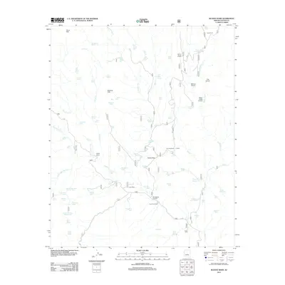
2012 Map of Bloody Basin
USGS Topo · Published 2012About this map
Red Creek Ranch and TT Ranch sit within the high-desert landscape of this Yavapai County quadrangle, where the terrain is deeply carved by seasonal drainage systems. The network of canyons, including Monroe Canyon and Yellow Jacket Canyon, dictates the placement of early ranching infrastructure. Vital water sources are scattered throughout the draws, evidenced by named springs like Metate Spring, Lizard Spring, and Coyote Spring. This area reflects a reliance on small-scale water management in a demanding environment, with numerous tanks such as Turtle Tank and Big Buck Tank supporting livestock operations. Human presence is centered on several established ranch sites and the Tangle Creek Cabin, while prominent natural landmarks like Turret Peak and the Mustang Hills serve as navigational anchors in the Bloody Basin.
Find a feature on this map
85 named features on this map. Tap any name to fly to it.
Don’t see what you’re looking for? This feature index may not catch every label — zoom into the map to look around manually.
Map Details
Editions of this 2012 Bloody Basin Map
This is the sole edition of this map. No revisions or reprints were ever made.
Other maps of this area

1887 · Verde
USGS Topo · 1:250,000

1892 · Verde
USGS Topo · 1:250,000

1929 · Turret Peak
USGS Topo · 1:125,000

1933 · Turret Peak
USGS Topo · 1:125,000

1954 · Holbrook
USGS Topo · 1:250,000

1957 · Holbrook
USGS Topo · 1:250,000

1958 · Holbrook
USGS Topo · 1:250,000

1960 · Holbrook
USGS Topo · 1:250,000
1967 · Brooklyn Peak
USGS Topo · 1:24,000
1967 · Chalk Mountain
USGS Topo · 1:24,000