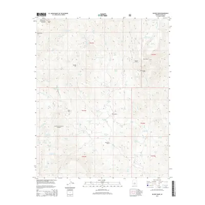
2014 Map of Bloody Basin
USGS Topo · Published 2014About this map
Bloody Basin defines this high-elevation landscape in Yavapai County, where the transition between the Prescott National Forest and the Tonto National Forest occurs across a complex system of plateaus and drainages. The area is characterized by dramatic elevation shifts, anchored by the prominent Turret Peak in the northwest and the expansive Rugged Mesa. Water management for cattle and wildlife is central to the land's utility, evidenced by the numerous named catchments such as Yellow Jacket Tank Number One, Beal Tank, and Pistol Tank. A labyrinth of drainages, including Red Creek, Middle Red Creek, and Hutch Gulch Creek, carves through the terrain, while landmarks like the Mustang Hills and Roundtree Canyon provide significant navigational points. The map details the primitive road network, including FR 278 and FR 24, which provide access to these remote reaches of Arizona's high desert wilderness.
Find a feature on this map
84 named features on this map. Tap any name to fly to it.
Don’t see what you’re looking for? This feature index may not catch every label — zoom into the map to look around manually.
Map Details
Editions of this 2014 Bloody Basin Map
This is the sole edition of this map. No revisions or reprints were ever made.
Other maps of this area

1887 · Verde
USGS Topo · 1:250,000

1892 · Verde
USGS Topo · 1:250,000

1929 · Turret Peak
USGS Topo · 1:125,000

1933 · Turret Peak
USGS Topo · 1:125,000

1954 · Holbrook
USGS Topo · 1:250,000

1957 · Holbrook
USGS Topo · 1:250,000

1958 · Holbrook
USGS Topo · 1:250,000

1960 · Holbrook
USGS Topo · 1:250,000
1967 · Brooklyn Peak
USGS Topo · 1:24,000
1967 · Chalk Mountain
USGS Topo · 1:24,000