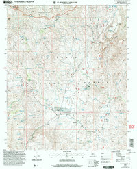
2004 Map of Bloody Basin
USGS Topo · Published 2006About this map
The Bloody Basin landscape within the central Arizona highlands presents a network of cattle ranching outposts and high-desert water sources across the transition between the Prescott Nat For and Tonto National Forest. Ranching operations are centered at the LX Bar Ranch and the Red Creek Ranch, while the surrounding terrain is defined by steep elevation changes around Turret Peak and the protected Pine Mountain Wilderness. The reliance on local hydrology is evident in the dense distribution of named springs and tanks, such as Cockleburr Spring and Mustang Tank, which supported livestock and the occasional industrial venture like the Marbles Mine. Administrative presence is noted at the Tangle Creek Admin Site, overseeing a region where travel relies heavily on 4WD routes and natural corridors like Roundtree Canyon and the drainage of Red Creek.
Find a feature on this map
95 named features on this map. Tap any name to fly to it.
Don’t see what you’re looking for? This feature index may not catch every label — zoom into the map to look around manually.
Map Details
Editions of this 2004 Bloody Basin Map
This is the sole edition of this map. No revisions or reprints were ever made.
Other maps of this area

1887 · Verde
USGS Topo · 1:250,000

1892 · Verde
USGS Topo · 1:250,000

1929 · Turret Peak
USGS Topo · 1:125,000

1933 · Turret Peak
USGS Topo · 1:125,000

1954 · Holbrook
USGS Topo · 1:250,000

1957 · Holbrook
USGS Topo · 1:250,000

1958 · Holbrook
USGS Topo · 1:250,000

1960 · Holbrook
USGS Topo · 1:250,000
1967 · Brooklyn Peak
USGS Topo · 1:24,000
1967 · Chalk Mountain
USGS Topo · 1:24,000