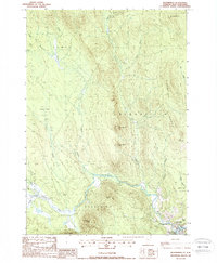
1988 Map of Bloomfield
USGS Topo · Published 1988About this map
Bloomfield stands at the confluence of the Nulhegan River and the Connecticut, serving as a focal point in this 1980s landscape on the Vermont-New Hampshire border. The terrain is defined by prominent peaks including Potash Mtn, French Mtn, and North Notch Mtn, which rise sharply from the river valley. To the west, the Yellow Bogs create a distinct wetland environment fed by the Yellow Branch and Black Branch.
Find a feature on this map
32 named features on this map. Tap any name to fly to it.
Don’t see what you’re looking for? This feature index may not catch every label — zoom into the map to look around manually.
Map Details
Editions of this 1988 Bloomfield Map
This is the sole edition of this map. No revisions or reprints were ever made.
Other maps of this area

1920 · Guildhall
USGS Topo · 1:62,500

1924 · Island Pond
USGS Topo · 1:48,000

1926 · Island Pond
USGS Topo · 1:62,500

1929 · Averill
USGS Topo · 1:62,500

1931 · Guildhall
USGS Topo · 1:48,000

1933 · Guildhall
USGS Topo · 1:48,000

1937 · Guildhall
USGS Topo · 1:62,500

1950 · Lewiston
USGS Topo · 1:250,000

1951 · Burke
USGS Topo · 1:62,500

1953 · Island Pond
USGS Topo · 1:62,500