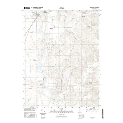
2016 Map of Bloomfield
USGS Topo · Published 2016About this map
The White River and its accompanying wetlands dominate this Greene County landscape, creating a broad, low-lying corridor between Worthington and Bloomfield. This 2016 survey illustrates the persistent importance of the river valley, where land use is dictated by the floodplains of Lattas Creek and Sloan Ditch. In the north, Point Commerce sits at the confluence of the river and Eel River, marking a site of early pioneer significance. On the higher ground east of the valley, the terrain becomes more dissected by drainages like Richland Creek and Wildcat Br, supporting smaller settlements such as Calvertville and Tulip. Genealogy researchers will find numerous rural burial grounds, including Stalcup Cem and Bucher Cem, preserved alongside the infrastructure of the Indiana Rail Road. The topographic data also highlights notable physical landmarks like Fairplay Mound and Persimmon Ridge, which rise above the surrounding bottomlands and rolling hills.
Find a feature on this map
133 named features on this map. Tap any name to fly to it.
Don’t see what you’re looking for? This feature index may not catch every label — zoom into the map to look around manually.
Map Details
Editions of this 2016 Bloomfield Map
This is the sole edition of this map. No revisions or reprints were ever made.
Other maps of this area

1908 · Bloomfield
USGS Topo · 1:62,500

1938 · Coal City
USGS Topo · 1:24,000

1938 · Switz City
USGS Topo · 1:24,000

1943 · Lyons
USGS Topo · 1:24,000

1947 · Switz City
USGS Topo · 1:24,000

1948 · Coal City
USGS Topo · 1:24,000

1950 · Arney
USGS Topo · 1:24,000

1950 · Switz City
USGS Topo · 1:24,000

1951 · Bloomfield
USGS Topo · 1:24,000
1953 · Coal City
USGS Topo · 1:24,000