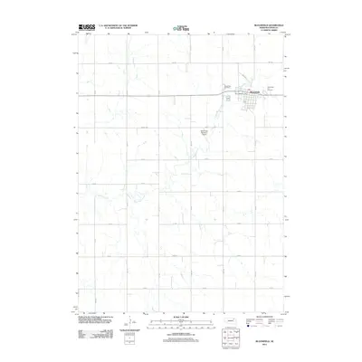
2011 Map of Bloomfield
USGS Topo · Published 2011About this map
Bloomfield serves as the central hub of this Knox County landscape, where the town’s grid is established north of Little Bazile Creek. The map documents a classic Midwestern agricultural pattern, with a rigorous section-line road network including 882 RD and 542 Ave carving the terrain into productive farm plots. Community life is centered around local staples such as the Bloomfield Post Office and the Bloomfield Fair Grounds on the eastern edge of town. For those tracing local history or family lineage, the Bloomfield Cemetery is clearly marked at the northern town boundary. The presence of the Bloomfield Municipal Airport south of the main settlement indicates the area’s continued role as a regional waypoint for commerce and transit in the early 21st century.
Find a feature on this map
21 named features on this map. Tap any name to fly to it.
Don’t see what you’re looking for? This feature index may not catch every label — zoom into the map to look around manually.
Map Details
Editions of this 2011 Bloomfield Map
This is the sole edition of this map. No revisions or reprints were ever made.
Other maps of this area

1955 · Sioux City
USGS Topo · 1:250,000

1958 · Sioux City
USGS Topo · 1:250,000

1959 · Sioux City
USGS Topo · 1:250,000

1968 · Bloomfield NE
USGS Topo · 1:24,000

1968 · Bloomfield SE
USGS Topo · 1:24,000

1971 · Wausa
USGS Topo · 1:24,000

1974 · Lindy
USGS Topo · 1:24,000

1974 · Midland
USGS Topo · 1:24,000

1974 · Bloomfield
USGS Topo · 1:24,000
1974 · Plainview NE
USGS Topo · 1:24,000