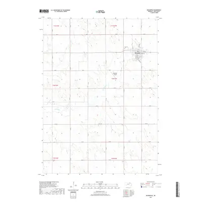
2017 Map of Bloomfield
USGS Topo · Published 2017About this map
Bloomfield serves as the primary hub in this portion of Knox County, centered around the intersection of Main St and Broadway St. The town's grid is well-defined, featuring established routes such as E Lincoln St and E Elm St, while the Bloomfield Cem sits on the northern outskirts. Outside the municipal center, the landscape is characterized by a precise network of section-line roads, including 542 Ave and 880 Rd, which facilitate access to the surrounding agricultural holdings. The Bloomfield Municipal Airport is situated south of the town center, positioned near the meandering path of Little Bazile Cr. This modern survey reflects the enduring organization of the Nebraska prairie, where the original Public Land Survey System boundaries, like t30n r3w, continue to dictate the placement of rural infrastructure and property lines.
Find a feature on this map
33 named features on this map. Tap any name to fly to it.
Don’t see what you’re looking for? This feature index may not catch every label — zoom into the map to look around manually.
Map Details
Editions of this 2017 Bloomfield Map
This is the sole edition of this map. No revisions or reprints were ever made.
Other maps of this area

1955 · Sioux City
USGS Topo · 1:250,000

1958 · Sioux City
USGS Topo · 1:250,000

1959 · Sioux City
USGS Topo · 1:250,000

1968 · Bloomfield NE
USGS Topo · 1:24,000

1968 · Bloomfield SE
USGS Topo · 1:24,000

1971 · Wausa
USGS Topo · 1:24,000

1974 · Lindy
USGS Topo · 1:24,000

1974 · Midland
USGS Topo · 1:24,000

1974 · Bloomfield
USGS Topo · 1:24,000
1974 · Plainview NE
USGS Topo · 1:24,000