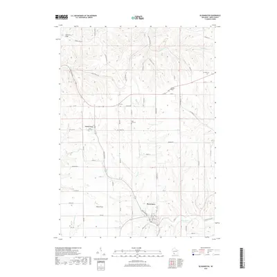
2018 Map of Bloomington
USGS Topo · Published 2018About this map
Patch Grove stands as the primary settlement within this southwestern Wisconsin landscape, situated at the intersection of prominent transport routes like the Great River Rd. The terrain is defined by the high ground of Military Ridge and Campbell Ridge, which separate various drainage basins including Millville Cr and the Blake Fork. This 2018 survey reveals a rural structure where local heritage is preserved in numerous burial grounds, such as Patch Grove Cem and the Saint Johns Cem near the southern edge. The area around Blake Prairie reflects the region's agricultural character, with a dense network of secondary roads—many named after family lineages or local geography like Hicklin Hollow Rd and Canyon Falls Rd—connecting scattered farmsteads across the dissected plateau. The map serves as a contemporary record of these established land patterns in Grant County.
Find a feature on this map
62 named features on this map. Tap any name to fly to it.
Don’t see what you’re looking for? This feature index may not catch every label — zoom into the map to look around manually.
Map Details
Editions of this 2018 Bloomington Map
This is the sole edition of this map. No revisions or reprints were ever made.
Other maps of this area

1900 · Lancaster
USGS Topo · 1:125,000

1902 · Elkader
USGS Topo · 1:125,000

1903 · Waukon
USGS Topo · 1:125,000

1904 · Lancaster
USGS Topo · 1:125,000

1908 · Lancaster
USGS Topo · 1:125,000

1926 · Wauzeka
USGS Topo · 1:62,500

1929 · Prairie Du Chien
USGS Topo · 1:62,500

1932 · Prairie Du Chien
USGS Topo · 1:62,500

1958 · La Crosse
USGS Topo · 1:250,000

1959 · Dubuque
USGS Topo · 1:250,000