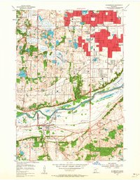
1954 Map of Bloomington
USGS Topo · Published 1964About this map
The Minnesota River corridor defines this mid-century landscape, acting as a natural boundary between the expanding northern suburbs and the more industrial and rural southern reaches. In Bloomington and Richfield, residential development is shown in red-tinted clusters, punctuated by numerous local institutions like St Richard Sch and Nativity Sch. The river valley itself remains dominated by water and industry, featuring Black Dog Lake and the significant transit hub at Port Cargill. Transport networks are central to the area's layout, with the Minneapolis Northfield and Southern and the Chicago and North Western railroads facilitating the movement of goods through Savage and toward the growing metropolitan centers. Cultural landmarks of the 1950s are evident, ranging from the Auto Club and Minnesota Valley Country Club to the Sandpit Ski Lift in the southern hills.
Find a feature on this map
62 named features on this map. Tap any name to fly to it.
Don’t see what you’re looking for? This feature index may not catch every label — zoom into the map to look around manually.
Map Details
Editions of this 1954 Bloomington Map
2 editions found
Other maps of this area

1896 · Minneapolis
USGS Topo · 1:62,500

1896 · St. Paul
USGS Topo · 1:62,500

1901 · Minneapolis
USGS Topo · 1:62,500

1951 · St. Paul West
USGS Topo · 1:24,000

1951 · St. Paul SW
USGS Topo · 1:24,000

1951 · St. Paul
USGS Topo · 1:62,500

1952 · Minneapolis South
USGS Topo · 1:24,000

1953 · Saint Paul
USGS Topo · 1:250,000

1954 · Hopkins
USGS Topo · 1:24,000

1954 · Bloomington
USGS Topo · 1:24,000