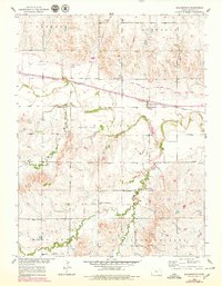
1953 Map of Bloomington
USGS Topo · Published 1979About this map
Bloomington and its surrounding rural townships represent a mid-century agricultural landscape defined by the winding course of the South Fork Solomon River. The arrival of the Osborne Canal and a network of siphons illustrate the importance of water management in this region of Osborne County. Settlement patterns follow the river valley and the Missouri Pacific railroad line, which bisects the territory from east to west. Local social life is anchored by community landmarks such as the United Brethren Ch and several small rural schools, including Rosedale Sch and Mayview Sch. The terrain is divided into named districts like Hawkeye, Lawrence, and Tilden, showing how early residents organized the rolling land between Medicine Creek and Kill Creek. Significant genealogical data is preserved in the locations of Bloomington Cem and Mount Hope Cem, providing fixed points for tracing family histories in this Kansas river valley.
Find a feature on this map
23 named features on this map. Tap any name to fly to it.
Don’t see what you’re looking for? This feature index may not catch every label — zoom into the map to look around manually.
Map Details
Editions of this 1953 Bloomington Map
3 editions found
Other maps of this area

1893 · Smith Center
USGS Topo · 1:125,000

1896 · Osborne
USGS Topo · 1:125,000

1953 · Bloomington
USGS Topo · 1:24,000

1953 · Osborne
USGS Topo · 1:24,000

1953 · Alton
USGS Topo · 1:24,000

1955 · Beloit
USGS Topo · 1:250,000

1959 · Beloit
USGS Topo · 1:250,000

1961 · Portis
USGS Topo · 1:24,000

1961 · Harlan
USGS Topo · 1:24,000

1961 · Gaylord SW
USGS Topo · 1:24,000