
1961 Map of Harlan
USGS Topo · Published 1962About this map
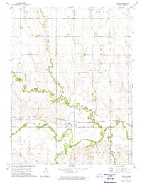
The North Fork Solomon River meanders across this rural landscape, defining a valley where water management is clearly a priority for local farmers. Numerous siphons and a flume are marked along the riverbanks, supporting agriculture in the townships of Houston, Hawkeye, and Lawrence. The small settlement of Harlan serves as a local hub, situated where the Missouri Pacific railroad crosses the river valley near Highway 281.
Find a feature on this map
25 named features on this map. Tap any name to fly to it.
Don’t see what you’re looking for? This feature index may not catch every label — zoom into the map to look around manually.
Map Details
Editions of this 1961 Harlan Map
This is the sole edition of this map. No revisions or reprints were ever made.
Other maps of this area

1893 · Smith Center
USGS Topo · 1:125,000

1896 · Osborne
USGS Topo · 1:125,000

1953 · Bloomington
USGS Topo · 1:24,000

1953 · Osborne
USGS Topo · 1:24,000

1953 · Alton
USGS Topo · 1:24,000

1955 · Beloit
USGS Topo · 1:250,000

1959 · Beloit
USGS Topo · 1:250,000

1961 · Portis
USGS Topo · 1:24,000

1961 · Gaylord SW
USGS Topo · 1:24,000
1973 · Cedar
USGS Topo · 1:24,000