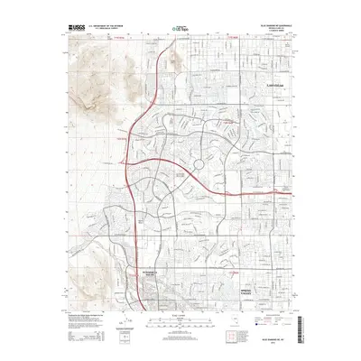
2015 Map of Blue Diamond NE
USGS Topo · Published 2015About this map
The western edge of Las Vegas meets the rising terrain of the Mojave Desert in this detailed survey, documenting the intensive suburban expansion at the foot of Lone Mtn. The landscape is dominated by the dense street networks of Summerlin South and Spring Valley, showing the transition from desert floor to master-planned communities. Significant infrastructure, such as the Bruce Woodbury Belt and Blue Diamond Rd (159), facilitates movement through this rapidly developed corridor. Beyond the residential tracts, specialized institutions like the Univ of Phoenix-Las Vegas Campus and the Le Cordon Bleu Coll of Culinary Arts-Las Vegas appear alongside local landmarks such as Memory Gardens. Further west, the map transitions into the natural topography of Box Canyon and the secluded Whitehead Springs, where the grid gives way to the open desert.
Find a feature on this map
34 named features on this map. Tap any name to fly to it.
Don’t see what you’re looking for? This feature index may not catch every label — zoom into the map to look around manually.
Map Details
Editions of this 2015 Blue Diamond NE Map
This is the sole edition of this map. No revisions or reprints were ever made.
Other maps of this area

1907 · Las Vegas
USGS Topo · 1:250,000

1908 · Las Vegas
USGS Topo · 1:250,000

1952 · Corn Creek Springs
USGS Topo · 1:62,500

1952 · Gass Peak
USGS Topo · 1:62,500

1952 · Blue Diamond
USGS Topo · 1:62,500

1952 · Las Vegas
USGS Topo · 1:62,500

1954 · Las Vegas
USGS Topo · 1:250,000

1957 · Las Vegas
USGS Topo · 1:250,000

1959 · Las Vegas
USGS Topo · 1:250,000

1962 · Las Vegas
USGS Topo · 1:250,000