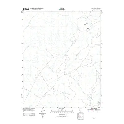
2011 Map of Blue Gap
USGS Topo · Published 2011About this map
Blue Gap and the settlement of Tahchee anchor this modern topographical study of the Chinle Agency region. The landscape is defined by the ephemeral drainage of Aspen Wash and the prominent rise of Taasahdi Dzil, which also gives its name to the water system in the northern sector. A complex network of secondary roads and trails, including Indian Rte 29 and Indian Rte 291, crisscrosses the high desert floor, revealing the modern transportation routes used by local residents. In the southeast corner, the Black Mountain Trading Post stands as a focal point for commerce and community, connected by Rte 8043. The map illustrates a contemporary view of this tribal landscape, where traditional landmarks and newer infrastructure meet.
Find a feature on this map
13 named features on this map. Tap any name to fly to it.
Don’t see what you’re looking for? This feature index may not catch every label — zoom into the map to look around manually.
Map Details
Editions of this 2011 Blue Gap Map
This is the sole edition of this map. No revisions or reprints were ever made.
Other maps of this area

1883 · Marsh Pass
USGS Topo · 1:250,000

1892 · Marsh Pass
USGS Topo · 1:250,000

1892 · Canyon De Chelly
USGS Topo · 1:250,000

1954 · Shiprock
USGS Topo · 1:250,000

1956 · Marble Canyon
USGS Topo · 1:250,000

1958 · Shiprock
USGS Topo · 1:250,000

1959 · Shiprock
USGS Topo · 1:250,000

1959 · Marble Canyon
USGS Topo · 1:250,000

1961 · Marble Canyon
USGS Topo · 1:250,000
1967 · Whippoorwill Spring
USGS Topo · 1:24,000
Featured Places
- Chinle Agency, AZ
- Blue Gap, Chinle Agency
- Tahchee, Chinle Agency
- Tókʼi Hazbįʼí, Chinle Agency
- Apache County, AZ