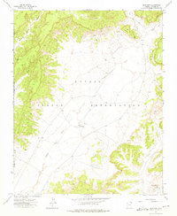
1972 Map of Blue Gap
USGS Topo · Published 1975About this map
The Navajo Indian Reservation landscape around Blue Gap is defined by a series of drainage washes and high desert terrain features in the early 1970s. This survey centers on the community hub of Blue Gap, featuring the Blue Gap Chapter House, Blue Gap Sch, and a small Cem. The settlement pattern follows the natural water sources and trail networks, with the Black Mountain Trading Post situated in the southeastern corner near a Well. Higher elevations are marked by landmarks like Taasahdi Dzil and Ramhead, while numerous water sources such as Donkey Spring and Yellow Spring dot the western canyons. The map illustrates a remote high-desert economy reliant on seasonal washes like Polacca Wash and Tah Chee Wash, where unimproved dirt roads and a Jeep Trail provide the primary means of traversal between scattered dwellings and localized resource points like an upland Mine.
Find a feature on this map
22 named features on this map. Tap any name to fly to it.
Don’t see what you’re looking for? This feature index may not catch every label — zoom into the map to look around manually.
Map Details
Editions of this 1972 Blue Gap Map
This is the sole edition of this map. No revisions or reprints were ever made.
Other maps of this area

1883 · Marsh Pass
USGS Topo · 1:250,000

1892 · Marsh Pass
USGS Topo · 1:250,000

1892 · Canyon De Chelly
USGS Topo · 1:250,000

1954 · Shiprock
USGS Topo · 1:250,000

1956 · Marble Canyon
USGS Topo · 1:250,000

1958 · Shiprock
USGS Topo · 1:250,000

1959 · Shiprock
USGS Topo · 1:250,000

1959 · Marble Canyon
USGS Topo · 1:250,000

1961 · Marble Canyon
USGS Topo · 1:250,000
1967 · Whippoorwill Spring
USGS Topo · 1:24,000
Featured Places
- Chinle Agency, AZ
- Tókʼi Hazbįʼí, Chinle Agency
- Tahchee, Chinle Agency
- Blue Gap, Chinle Agency
- Apache County, AZ