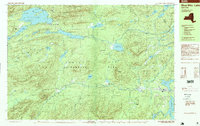
1997 Map of Blue Mtn Lake
USGS Topo · Published 1999About this map
Blue Mountain Lake sits at the heart of this late-twentieth-century landscape within the Adirondack Park. The area is defined by its complex network of waterways, ranging from the interconnected Eagle Nest and Utowana Lake to the secluded Mitchell Ponds and Cascade Pond. The settlement of Blue Mountain Lake serves as a primary hub, while the presence of Forest House and a Cem near the Lake Durant shoreline points to a history of habitation and seasonal recreation. High elevations like Blue Mountain and Stark Hills tower over the Rock River and Cedar River basins, illustrating the traditional Adirondack wilderness pattern. Human activity is evidenced by a Snowmobile Trail and a Golf Course, showing the transition of the region into a modern recreational destination while maintaining its protected forest character.
Find a feature on this map
72 named features on this map. Tap any name to fly to it.
Don’t see what you’re looking for? This feature index may not catch every label — zoom into the map to look around manually.
Map Details
Editions of this 1997 Blue Mtn Lake Map
This is the sole edition of this map. No revisions or reprints were ever made.
Other maps of this area

1898 · Newcomb
USGS Topo · 1:62,500

1898 · Thirteenth Lake
USGS Topo · 1:62,500

1899 · Indian Lake
USGS Topo · 1:62,500

1900 · Canada Lake
USGS Topo · 1:62,500

1901 · Newcomb
USGS Topo · 1:62,500

1902 · Indian Lake
USGS Topo · 1:62,500

1903 · West Canada Lakes
USGS Topo · 1:62,500

1903 · Raquette Lake
USGS Topo · 1:62,500

1903 · Blue Mountain
USGS Topo · 1:62,500

1950 · Utica
USGS Topo · 1:250,000