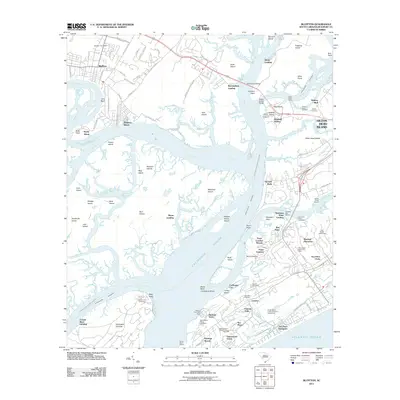
2011 Map of Bluffton
USGS Topo · Published 2011About this map
The May River and Calibogue Sound define the intricate tidal geography of the Lowcountry in this 2011 survey, showing the transition from the mainland Bluffton settlement to the developed reaches of Hilton Head Island. The map records a landscape of modern residential growth alongside deep-rooted historical markers, such as Stoney Cemetery and Jenkins Island Cemetery. The Intracoastal Waterway cuts through Skull Creek, serving as a vital artery for maritime traffic near Windmill Harbor and Buckingham Landing. To the south, the planned communities of Sea Pines Plantation and Wexford Plantation surround critical coastal infrastructure like the Harbour Town Yacht Basin. The presence of numerous family and community burial grounds, including Lawton Cemetery and Haig Point Cemetery, provides essential data for genealogical research in a region where historical land use remains visible despite modern suburban expansion.
Find a feature on this map
112 named features on this map. Tap any name to fly to it.
Don’t see what you’re looking for? This feature index may not catch every label — zoom into the map to look around manually.
Map Details
Editions of this 2011 Bluffton Map
This is the sole edition of this map. No revisions or reprints were ever made.
Other maps of this area

1920 · Okatie
USGS Topo · 1:62,500

1920 · Hilton Head
USGS Topo · 1:62,500

1920 · Bluffton
USGS Topo · 1:62,500

1942 · Okatie
USGS Topo · 1:62,500

1944 · Fort Fremont
USGS Topo · 1:62,500

1945 · Bluffton
USGS Topo · 1:62,500

1945 · Hilton Head
USGS Topo · 1:62,500

1947 · Savannah
USGS Topo · 1:250,000

1948 · Savannah
USGS Topo · 1:250,000
1955 · Pritchardville
USGS Topo · 1:24,000