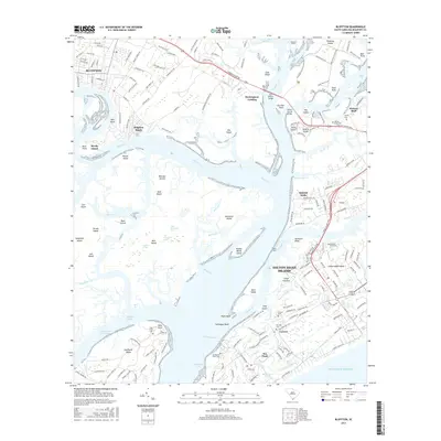
2017 Map of Bluffton
USGS Topo · Published 2017About this map
Bluffton and the surrounding Lowcountry wetlands are documented in this 2017 study, showing the established coastal communities of Hilton Head Island and its various subdivisions like Sea Pines and Lawton. The map traces the intricate water systems and islands that define the region, from the wide May River to smaller channels like Jarvis Cr and Broad Cr. A series of bridges, including the Karl Bowers Bridge and Wilton Graves Bridge, provide the vital links between the mainland and islands like Pinckney Island and Jenkins Island. For local historians and genealogists, the map is remarkably detailed regarding burial grounds, marking sites such as Stoney Cem, Jenkins Island Cem, and the Braddocks Point Cem near the southern tip of Sea Pines. The landscape is a complex mix of developed resort and residential areas alongside protected environments like Middle Marsh Island and Barataria Island.
Find a feature on this map
189 named features on this map. Tap any name to fly to it.
Don’t see what you’re looking for? This feature index may not catch every label — zoom into the map to look around manually.
Map Details
Editions of this 2017 Bluffton Map
This is the sole edition of this map. No revisions or reprints were ever made.
Other maps of this area

1920 · Okatie
USGS Topo · 1:62,500

1920 · Hilton Head
USGS Topo · 1:62,500

1920 · Bluffton
USGS Topo · 1:62,500

1942 · Okatie
USGS Topo · 1:62,500

1944 · Fort Fremont
USGS Topo · 1:62,500

1945 · Bluffton
USGS Topo · 1:62,500

1945 · Hilton Head
USGS Topo · 1:62,500

1947 · Savannah
USGS Topo · 1:250,000

1948 · Savannah
USGS Topo · 1:250,000
1955 · Pritchardville
USGS Topo · 1:24,000