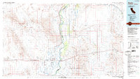
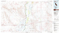
1986 Map of Blythe
USGS Topo · Published 1986About this map
The Colorado River serves as the central artery and state boundary for this mid-1980s landscape, dividing the agricultural vitality of California from the arid reaches of Arizona. In the Palo Verde Valley, a complex network of features like the Main Drain, Lateral Drain, and Levee demonstrate the intensive irrigation required to sustain the communities of Blythe, East Blythe, and Ripley. The Atchison Topeka and Santa Fe railroad corridor cuts through the Palo Verde Mesa, connecting the valley to the remote settlement of Midland in the north.
Find a feature on this map
86 named features on this map. Tap any name to fly to it.
Don’t see what you’re looking for? This feature index may not catch every label — zoom into the map to look around manually.
Map Details
Editions of this 1986 Blythe Map
3 editions found

Other maps of this area

1911 · Parker
USGS Topo · 1:125,000

1923 · Signal
USGS Topo · 1:250,000

1930 · Linskey
USGS Topo · 1:62,500

1931 · Moon Mtn
USGS Topo · 1:62,500

1932 · Moon Mtn
USGS Topo · 1:62,500

1933 · Cunningham Mtn
USGS Topo · 1:48,000

1934 · Trigo Peaks
USGS Topo · 1:48,000
1939 · Trigo Peaks
USGS Topo · 1:62,500

1940 · Dome Rock Mts
USGS Topo · 1:62,500

1942 · Signal
USGS Topo · 1:250,000