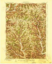
1933 Map of Boaz
USGS Topo · Published 1933About this map
Boaz and the surrounding Driftless Area of Richland County are defined by a complex network of ridges and narrow valleys that shaped the settlement patterns of the early twentieth century. The Kickapoo River and Knapp Creek carve through this landscape, creating natural corridors for crossroads like Kickapoo Center and Rolling Ground. Unlike many other regions where towns are the primary focal points, this area is characterized by an exceptionally dense distribution of rural institutions. Neighborhood schools such as Eckleberry School, Higgins School, and Sugar Grove School are spaced nearly every mile or two along the ridges, alongside country congregations at St Philips Church and Hopewell Church. This map reveals how local life was organized around these small community centers, with numerous family-named landmarks like Wanless Ridge and Babb Ridge identifying the terrain of individual farms and homesteads.
Find a feature on this map
110 named features on this map. Tap any name to fly to it.
Don’t see what you’re looking for? This feature index may not catch every label — zoom into the map to look around manually.
Map Details
Editions of this 1933 Boaz Map
2 editions found
Other maps of this area

1905 · Richland Center
USGS Topo · 1:125,000

1923 · Viroqua
USGS Topo · 1:62,500

1924 · Gays Mills
USGS Topo · 1:62,500

1926 · Gays Mills
USGS Topo · 1:62,500

1926 · Viroqua
USGS Topo · 1:62,500

1926 · La Farge
USGS Topo · 1:62,500

1926 · Wauzeka
USGS Topo · 1:62,500
1927 · Hillsboro
USGS Topo · 1:62,500

1933 · Boaz
USGS Topo · 1:62,500

1933 · Boscobel
USGS Topo · 1:62,500