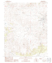
1989 Map of Bodie
USGS Topo · Published 1989About this map
Bodie and its surrounding high-desert mining landscape are captured in this 1980s-era topographical record of the Bodie Hills. The townsite is shown within the State Historical Park, including its State Historical Park Cemetery and various remnants of the district's hard-rock gold mining legacy. The complex network of prospects and established sites like the Red Cloud Mine and Silver Hill Mine are scattered across the slopes of Bodie Bluff, indicating the extensive subterranean workings that once drove this remote settlement.
Find a feature on this map
28 named features on this map. Tap any name to fly to it.
Don’t see what you’re looking for? This feature index may not catch every label — zoom into the map to look around manually.
Map Details
Editions of this 1989 Bodie Map
This is the sole edition of this map. No revisions or reprints were ever made.
Other maps of this area

1909 · Hawthorne
USGS Topo · 1:250,000

1909 · Bridgeport
USGS Topo · 1:125,000

1911 · Bridgeport
USGS Topo · 1:125,000

1911 · Hawthorne
USGS Topo · 1:250,000

1915 · Hawthorne
USGS Topo · 1:250,000

1920 · Bridgeport
USGS Topo · 1:125,000

1948 · Walker Lake
USGS Topo · 1:250,000
1956 · Aurora
USGS Topo · 1:62,500

1957 · Walker Lake
USGS Topo · 1:250,000
1958 · Bodie
USGS Topo · 1:62,500