
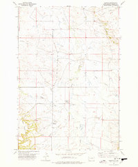
1973 Map of Bog Creek
USGS Topo · Published 1978About this map
East Short Pine Hills dominate the southwestern corner of this Harding County landscape, creating a dramatic topographical transition in the northwestern South Dakota plains. The drainage patterns here are particularly distinct, with the South Fork Grand River flowing through the northern portion of the quadrangle while the North Fork Moreau River cuts across the southeast. Between these major water systems, the prominent escarpment known as The Jumpoff winds through the center of the map, marking a significant geologic break in the terrain. Human presence is sparse in this open country, represented primarily by the Ruona Ranch and various unimproved roads that navigate the complex network of draws and creeks like Chalk Butte Draw and Buffalo Creek. The map effectively illustrates the vast watershed divide that separates the Grand and Moreau river systems in this ranching territory.
Find a feature on this map
12 named features on this map. Tap any name to fly to it.
Don’t see what you’re looking for? This feature index may not catch every label — zoom into the map to look around manually.
Map Details
Editions of this 1973 Bog Creek Map
This is the sole edition of this map. No revisions or reprints were ever made.
Other maps of this area

1935 · Harding
USGS Topo · 1:125,000

1935 · Buffalo
USGS Topo · 1:125,000

1954 · Lemmon
USGS Topo · 1:250,000

1957 · Lemmon
USGS Topo · 1:250,000

1971 · Buffalo
USGS Topo · 1:24,000

1971 · Saddle Butte
USGS Topo · 1:24,000

1973 · Redig
USGS Topo · 1:24,000

1973 · Hells Canyon
USGS Topo · 1:24,000

1974 · Pine Spring
USGS Topo · 1:24,000
1977 · Harding
USGS Topo · 1:24,000