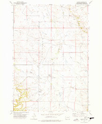
1977 Map of Harding
USGS Topo · Published 1977About this map
The small settlement of Harding sits at the base of the West Short Pine Hills in this mid-1970s survey. The landscape is defined by the complex drainage systems of the Little Grand River and its numerous tributaries, including Valley Creek, Waterhole Creek, and Brush Creek. Evidence of local ranching or agricultural infrastructure is visible through the presence of several Well sites and a Landing Strip located north of Harding.
Find a feature on this map
15 named features on this map. Tap any name to fly to it.
Don’t see what you’re looking for? This feature index may not catch every label — zoom into the map to look around manually.
Map Details
Editions of this 1977 Harding Map
This is the sole edition of this map. No revisions or reprints were ever made.
Other maps of this area

1935 · Harding
USGS Topo · 1:125,000

1935 · Buffalo
USGS Topo · 1:125,000

1954 · Lemmon
USGS Topo · 1:250,000

1957 · Lemmon
USGS Topo · 1:250,000

1971 · Saddle Butte
USGS Topo · 1:24,000

1973 · Bog Creek
USGS Topo · 1:24,000

1973 · Hells Canyon
USGS Topo · 1:24,000

1974 · Pine Spring
USGS Topo · 1:24,000
1977 · Camp Crook
USGS Topo · 1:24,000
1978 · J K Butte
USGS Topo · 1:24,000