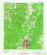
1984 Map of Bogalusa
USGS Topo · Published 1984About this map
The Pearl River and Bogue Chitto River define this mid-1980s landscape, winding through a complex system of sloughs and swamps along the Louisiana and Mississippi border. The city of Bogalusa stands as a primary hub on the western side of the river, while Picayune and Poplarville anchor the eastern Mississippi section. This survey captures a region heavily influenced by large-scale conservation and academic land management, including the De Soto National Forest and the expansive Bogue Chitto National Wildlife Refuge.
Find a feature on this map
157 named features on this map. Tap any name to fly to it.
Don’t see what you’re looking for? This feature index may not catch every label — zoom into the map to look around manually.
Map Details
Editions of this 1984 Bogalusa Map
This is the sole edition of this map. No revisions or reprints were ever made.
Historical Maps of Gulfport Through Time
3 maps found