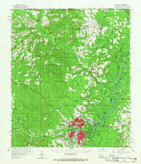
1959 Map of Bogalusa
USGS Topo · Published 1965About this map
The Illinois Central Railroad corridor anchors this 1959 study of the Louisiana-Mississippi borderlands, cutting through Bogalusa and the timber-rich parish interior. The landscape is defined by the winding course of the Pearl River and its numerous oxbow lakes, including Manning Lake and Old Jail Lake, which suggest a long history of seasonal flooding and shifting riverbeds. This era shows the community at a height of mid-century development, evidenced by the presence of the Bogalusa Airport, a Drive-in Theater, and Radio Station (WIKC).
Find a feature on this map
106 named features on this map. Tap any name to fly to it.
Don’t see what you’re looking for? This feature index may not catch every label — zoom into the map to look around manually.
Map Details
Editions of this 1959 Bogalusa Map
2 editions found

Other maps of this area

1939 · Zona
USGS Topo · 1:31,680

1942 · Thigpen
USGS Topo · 1:31,680

1942 · Rio
USGS Topo · 1:31,680

1942 · Pools Bluff
USGS Topo · 1:31,680

1942 · Thomas
USGS Topo · 1:31,680

1949 · Bogalusa East
USGS Topo · 1:31,680

1949 · Angie
USGS Topo · 1:31,680

1949 · Bogalusa West
USGS Topo · 1:31,680

1950 · Crains Creek
USGS Topo · 1:31,680

1953 · Hattiesburg
USGS Topo · 1:250,000