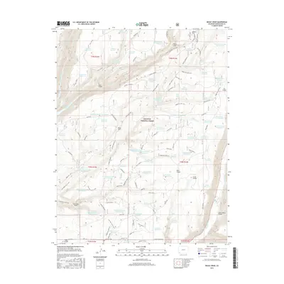
2016 Map of Boggy Draw
USGS Topo · Published 2016About this map
San Juan National Forest lands dominate this high-altitude landscape in southwest Colorado, where a complex network of canyons and reservoirs speaks to the area's vital water management and timber history. Named features like Sawmill Reservoir and Railroad Reservoir suggest the early industrial heritage of the plateau, while the presence of the McPhee Reservoir shoreline marks the western edge of the quadrangle. The terrain is deeply incised by Trail Canyon and Bean Canyon, creating a rugged relief that has historically challenged movement through the region.
Find a feature on this map
85 named features on this map. Tap any name to fly to it.
Don’t see what you’re looking for? This feature index may not catch every label — zoom into the map to look around manually.
Map Details
Editions of this 2016 Boggy Draw Map
This is the sole edition of this map. No revisions or reprints were ever made.
Other maps of this area

1956 · Cortez
USGS Topo · 1:250,000

1958 · Cortez
USGS Topo · 1:250,000

1959 · Cortez
USGS Topo · 1:250,000

1962 · Cortez
USGS Topo · 1:250,000

1963 · Stoner
USGS Topo · 1:24,000
1963 · Nipple Mountain
USGS Topo · 1:24,000

1965 · Willow Spring
USGS Topo · 1:24,000

1965 · Dolores East
USGS Topo · 1:24,000

1965 · Dolores West
USGS Topo · 1:24,000
1965 · Millwood
USGS Topo · 1:24,000