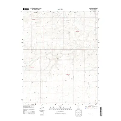
2013 Map of Boiler Gap
USGS Topo · Published 2013About this map
The high plains of Union County in northeast New Mexico are defined by a network of drainage systems and isolated landmarks in this early twenty-first-century survey. Boiler Gap and Sand Gap serve as key terrain features, marking passages through the undulating topography that transitions into deeper carved waters like Turkwy Canyon. The settlement of Thomas sits near the western edge of the quadrangle, connected to the wider region by a grid of rural routes including Garcia Rd and Campbell Rd.
Find a feature on this map
21 named features on this map. Tap any name to fly to it.
Don’t see what you’re looking for? This feature index may not catch every label — zoom into the map to look around manually.
Map Details
Editions of this 2013 Boiler Gap Map
This is the sole edition of this map. No revisions or reprints were ever made.
Other maps of this area

1954 · Dalhart
USGS Topo · 1:250,000

1958 · Dalhart
USGS Topo · 1:250,000

1962 · Dalhart
USGS Topo · 1:250,000

1972 · Mc Laughlin Bridge
USGS Topo · 1:24,000

1972 · Mount Dora
USGS Topo · 1:24,000

1972 · Bible Top Butte
USGS Topo · 1:24,000
1972 · Guy
USGS Topo · 1:24,000

1972 · Cuates School
USGS Topo · 1:24,000
1972 · Fiddler Springs
USGS Topo · 1:24,000
1972 · Boiler Gap
USGS Topo · 1:24,000