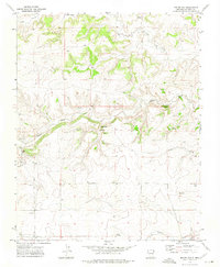
1972 Map of Boiler Gap
USGS Topo · Published 1975About this map
Boiler Gap and Sand Gap provide natural passage through this high plains landscape in Union County, where the 1970s cattle-ranching economy relied heavily on groundwater. Evidence of this necessity appears in the named water sources and infrastructure, such as the Boiler Gap Spring, Vialpando Windmill, and Tellott Windmill. A network of intermittent drainages, including Corrumpa Creek and Rafael Creek, define the topography, cutting through the terrain between the mesas. For genealogists and local historians, the map identifies specific family-named sites and landmarks like Graves and Wood, along with a local Gravel Pit, providing specific coordinates for mid-century land use and human presence in this sparsely populated region of northeastern New Mexico.
Find a feature on this map
17 named features on this map. Tap any name to fly to it.
Don’t see what you’re looking for? This feature index may not catch every label — zoom into the map to look around manually.
Map Details
Editions of this 1972 Boiler Gap Map
This is the sole edition of this map. No revisions or reprints were ever made.
Other maps of this area

1954 · Dalhart
USGS Topo · 1:250,000

1958 · Dalhart
USGS Topo · 1:250,000

1962 · Dalhart
USGS Topo · 1:250,000

1972 · Mc Laughlin Bridge
USGS Topo · 1:24,000

1972 · Mount Dora
USGS Topo · 1:24,000

1972 · Bible Top Butte
USGS Topo · 1:24,000
1972 · Guy
USGS Topo · 1:24,000

1972 · Cuates School
USGS Topo · 1:24,000
1972 · Fiddler Springs
USGS Topo · 1:24,000
1973 · Blind Gap
USGS Topo · 1:24,000