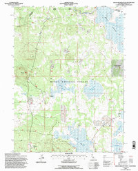
1993 Map of Boles Meadow West
USGS Topo · Published 1996About this map
Modoc National Forest encompasses this high-elevation plateau region, where water management is central to the landscape. Numerous reservoirs and seasonal catchments like Surveyors Valley Reservoir, Deadhorse Reservoir Flat, and Reservoir M dot the terrain, supporting the area's cattle-ranching operations. The presence of Wildhorse Cow Camp and the aptly named Gas Drum Flat points to the practical infrastructure required for land use in this part of California during the late twentieth century.
Find a feature on this map
22 named features on this map. Tap any name to fly to it.
Don’t see what you’re looking for? This feature index may not catch every label — zoom into the map to look around manually.
Map Details
Editions of this 1993 Boles Meadow West Map
This is the sole edition of this map. No revisions or reprints were ever made.
Other maps of this area

1886 · Alturas
USGS Topo · 1:250,000

1886 · Modoc Lava Bed
USGS Topo · 1:250,000

1892 · Modoc Lava-Bed
USGS Topo · 1:250,000

1892 · Alturas
USGS Topo · 1:250,000

1951 · Clear Lake Reservoir
USGS Topo · 1:62,500

1952 · Hackamore
USGS Topo · 1:62,500

1954 · Alturas
USGS Topo · 1:250,000

1958 · Alturas
USGS Topo · 1:250,000

1962 · Alturas
USGS Topo · 1:250,000

1962 · Steele Swamp
USGS Topo · 1:62,500