
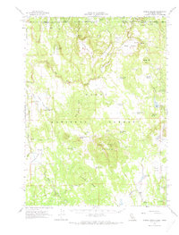
1962 Map of Steele Swamp
USGS Topo · Published 1964About this map
Steele Swamp and the high desert rangelands of the Modoc National Forest define this 1962 landscape along the California-Oregon border. The survey details an era of active land management and remote ranching, where isolated outposts like Steele Swamp Ranch and Hager Ranch operated far from paved roads. A complex system of livestock water improvements is evident, including the Baseball Reservoir, Picnic Grove Reservoir, and various tanks like Kellogg Tank, illustrating the vital infrastructure required for high-altitude grazing.
Find a feature on this map
75 named features on this map. Tap any name to fly to it.
Don’t see what you’re looking for? This feature index may not catch every label — zoom into the map to look around manually.
Map Details
Editions of this 1962 Steele Swamp Map
2 editions found
Other maps of this area

1886 · Alturas
USGS Topo · 1:250,000

1886 · Modoc Lava Bed
USGS Topo · 1:250,000

1889 · Klamath
USGS Topo · 1:250,000

1892 · Modoc Lava-Bed
USGS Topo · 1:250,000

1892 · Alturas
USGS Topo · 1:250,000

1894 · Klamath
USGS Topo · 1:250,000

1951 · Clear Lake Reservoir
USGS Topo · 1:62,500

1952 · Hackamore
USGS Topo · 1:62,500

1954 · Alturas
USGS Topo · 1:250,000

1955 · Klamath Falls
USGS Topo · 1:250,000