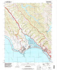
1993 Map of Bolinas
USGS Topo · Published 1997About this map
The San Andreas Rift Zone creates a striking linear depression through this coastal landscape, separating the wooded ridges from the maritime communities of Bolinas and Stinson Beach. This 1993 revision, based on earlier mid-century photogrammetry, highlights the unique geography of Bolinas Lagoon and Kent Island, protected by the Bolinas Quail State Refuge. The map reveals the area's rural character and hidden infrastructure, from the Cem near the lagoon to the McKinnan Gulch Mine tucked into the slopes of Mt Tamalpais State Park. North of the lagoon, the small settlement of Woodville sits along the Shoreline Highway, while to the south, the Hill 640 Military Res overlooks the entrance to Bolinas Bay, marking a legacy of coastal defense near the Pacific Ocean.
Find a feature on this map
59 named features on this map. Tap any name to fly to it.
Don’t see what you’re looking for? This feature index may not catch every label — zoom into the map to look around manually.
Map Details
Editions of this 1993 Bolinas Map
This is the sole edition of this map. No revisions or reprints were ever made.
Other maps of this area

1897 · Tamalpais
USGS Topo · 1:62,500

1914 · Petaluma
USGS Topo · 1:62,500

1916 · Point Reyes
USGS Topo · 1:48,000

1918 · Point Reyes
USGS Topo · 1:62,500

1941 · Tamalpais
USGS Topo · 1:62,500

1942 · Petaluma
USGS Topo · 1:62,500

1947 · Santa Rosa
USGS Topo · 1:250,000

1947 · San Francisco
USGS Topo · 1:250,000

1948 · San Francisco
USGS Topo · 1:250,000

1949 · Santa Rosa
USGS Topo · 1:250,000