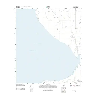
2011 Map of Bon Secour Bay
USGS Topo · Published 2011About this map
Bon Secour Bay and the shoreline of Gulf of Mexico dominate this 2011 survey of the Alabama coast. The landscape is a mix of residential growth and energy production, with the South Weeks Bay Gas Field and Cypress Point Gas Field situated just inland from the water. Small settlements like Gasque and Dorgans Lodge anchor the local geography, while the interior is crisscrossed by roads such as Magnolia Springs Hwy and Co Road 12. Genealogists may find value in the presence of Shellbank Cemetery and Miller Memorial Cemetery, which serve as quiet markers of the community's history. The coastal edge features notable points of interest for boaters and locals alike, including Cypress Point, Seymour Bluff, and Frosts Landing.
Find a feature on this map
49 named features on this map. Tap any name to fly to it.
Don’t see what you’re looking for? This feature index may not catch every label — zoom into the map to look around manually.
Map Details
Editions of this 2011 Bon Secour Bay Map
This is the sole edition of this map. No revisions or reprints were ever made.
Other maps of this area

1921 · Bon Secour
USGS Topo · 1:62,500

1921 · Point Clear
USGS Topo · 1:62,500

1941 · Foley
USGS Topo · 1:62,500

1941 · Weeks Bay
USGS Topo · 1:62,500

1943 · Weeks Bay
USGS Topo · 1:62,500

1943 · Foley
USGS Topo · 1:62,500
1956 · Point Clear
USGS Topo · 1:24,000

1957 · Pensacola
USGS Topo · 1:250,000

1959 · Pensacola
USGS Topo · 1:250,000

1960 · Pensacola
USGS Topo · 1:250,000