Loading...
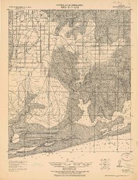
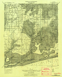
Loading map...1921 Map of Bon Secour
USGS Topo · Published 1921About this map
Coastal Baldwin County unfolds in this reconnaissance survey, where the Ft. Morgan and Summerdale RR tracks south through Summerdale and Foley toward the coast. The landscape is defined by its complex aquatic network, from the tidal reaches of Bon Secour River and Oyster Bay to the protected waters of Wolf Bay. Strategic coastal points are noted at Josephine P.O. and the U.S. Reservation near the Perdido Entrance.
Find a feature on this map
40 named features on this map. Tap any name to fly to it.
Don’t see what you’re looking for? This feature index may not catch every label — zoom into the map to look around manually.
Map Details
Date Portrayed1921
Date Published1921
PublisherU.S. Geological Survey
Map TypeTopographic
Scale1:62,500
Physical Dimensions17.08 x 22.17 inches
Editions of this 1921 Bon Secour Map
2 editions found
Historical Maps of Foley Through Time
1 maps found
Featured Locations
Source Details
SourceU.S. Geological Survey
CopyrightPublic Domain