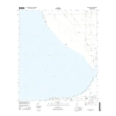
2014 Map of Bon Secour Bay
USGS Topo · Published 2014About this map
Bon Secour Bay dominates this coastal landscape, showing the transition from the open waters of the bay to the residential development and wetlands of the Fort Morgan Peninsula. The Intracoastal Waterway cuts across the bay, serving as a critical navigation artery south of the small settlement at Gasque. Along the narrow peninsula to the south, the expansion of Gulf Shores is evident, with detailed street layouts reaching toward the shoreline. Local history is anchored by sites like Shellbank Cem and the Miller Memorial Cem, which sit amidst a network of bayous and bluffs including Shellbank Bayou and Seymour Bluff. The northern shore is marked by agricultural roads and family-named landmarks like Bass Field, illustrating the area's mix of rural heritage and modern coastal growth.
Find a feature on this map
50 named features on this map. Tap any name to fly to it.
Don’t see what you’re looking for? This feature index may not catch every label — zoom into the map to look around manually.
Map Details
Editions of this 2014 Bon Secour Bay Map
This is the sole edition of this map. No revisions or reprints were ever made.
Other maps of this area

1921 · Bon Secour
USGS Topo · 1:62,500

1921 · Point Clear
USGS Topo · 1:62,500

1941 · Foley
USGS Topo · 1:62,500

1941 · Weeks Bay
USGS Topo · 1:62,500

1943 · Weeks Bay
USGS Topo · 1:62,500

1943 · Foley
USGS Topo · 1:62,500
1956 · Point Clear
USGS Topo · 1:24,000

1957 · Pensacola
USGS Topo · 1:250,000

1959 · Pensacola
USGS Topo · 1:250,000

1960 · Pensacola
USGS Topo · 1:250,000