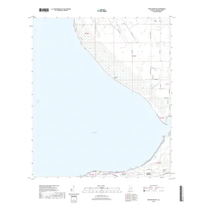
2018 Map of Bon Secour Bay
USGS Topo · Published 2018About this map
Fort Morgan Peninsula stretches across the southern edge of this survey, separating the Intracoastal Waterway from the northern expanse of Bon Secour Bay. The landscape is defined by the transition from coastal wetlands and bayous, such as Shellbank Bayou and Skunk Bayou, to the established roadways of Gulf Shores. The northern shore is marked by prominent landmarks like Cypress Point and Seymour Bluff, while the inland areas are interlaced with local drainages including Nolte Cr and Weeks Cr. For those researching local heritage, the map identifies significant burial sites including Shellbank Cem near the community of Gasque and Miller Memorial Cem further east. This modern charting provides a clear view of the road network, from Dixie Graves Pkwy to the more rural reaches of Magnolia Springs Hwy, capturing the balance between coastal preservation and community growth.
Find a feature on this map
48 named features on this map. Tap any name to fly to it.
Don’t see what you’re looking for? This feature index may not catch every label — zoom into the map to look around manually.
Map Details
Editions of this 2018 Bon Secour Bay Map
This is the sole edition of this map. No revisions or reprints were ever made.
Other maps of this area

1921 · Bon Secour
USGS Topo · 1:62,500

1921 · Point Clear
USGS Topo · 1:62,500

1941 · Foley
USGS Topo · 1:62,500

1941 · Weeks Bay
USGS Topo · 1:62,500

1943 · Weeks Bay
USGS Topo · 1:62,500

1943 · Foley
USGS Topo · 1:62,500
1956 · Point Clear
USGS Topo · 1:24,000

1957 · Pensacola
USGS Topo · 1:250,000

1959 · Pensacola
USGS Topo · 1:250,000

1960 · Pensacola
USGS Topo · 1:250,000